Army Rumour Service

Register a free account today to join our community
Once signed in, you'll be able to participate on this site, connect with other members through your own private inbox and will receive smaller adverts!

West Germany Cold War Locations Map

I had wondered just how quickly these points could be bought into operation and having pre-prepared bridges/ferries makes total sense.
If there are any former RE on here who could provide more information it would be greatly received.
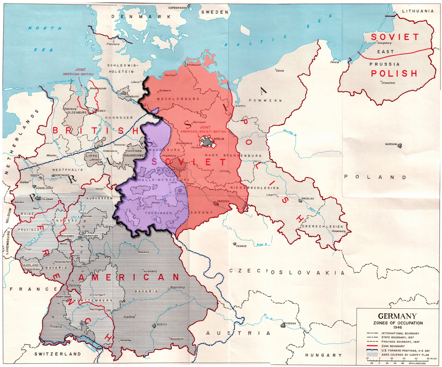
I do see that in the US sectors the points I have found so far are much fewer however, they do tend to be much larger:

View attachment 584240
One of the last big divisional exercises, 1989 iirc, found us approaching Herford, which had banned military movement during the daily rush hour, so the regiment was diverted into a riverside field to wait.
On the opposite bank was a Bundeswehr bridging unit, not taking part in the exercise, while the regiment was armoured engineers with avlbs, neither of which helped.
Sent out on a recce, a landrover dicovered a small, civilian chain ferry down a single track lane, that could carry 2 or 3 cars at a time, for a small fee.
The ferryman earned his retirement fund that day, as a long line of 432s, Spartans, trucks and trailers slowly crossed, often with the gunwhales awash.
 
Any luck with Oxford Barracks, Munster?
I'll get it added on Monday (TBH, I've only just located it!). Been tagging up all the barracks I can find now. Just like the former E Germany, may have been flattened but there are a surprising amount that look like they have been empty since the 90's!
 
I used to contribute to a site called BAOR Locations. I supplied the GoogleEarth material in relation to BAOR, Berlin, Belgium, Netherlands, British Troops Austria etc. The original webmaster of BAOR Locations had to give up administering the site. Ostensibly his role was taken over by other(s) but the site has remained very much as it was when Phil gave it up with nothing being updated.

My page fell down and was never repaired.

I attach the BAOR/Berlin bit which has been considerably updated and amended since its inclusion on BAOR Locations. It is somewhat more comprehensive than @Speedy's version, but as it is the work of many years that is hardly surprising. I've had a quick whizz through Speedy's version and it's a creditable first effort with a couple of errors. (eg; The Barossa Barracks shown in Hemer was a former Hitler era barracks, Blücher Kaserne, (later a Belgian barracks; Ardennes Casernes). Barossa Barracks was further to the east housed in what was formerly a 'modern' Canadian barracks (Fort MacLeod), which was a hutted camp purpose-built after the war.

Any info re: glaring errors, omissions or additions gratefully received.
 

Attachments

  • Germany.zip
    128 KB · Views: 60
Last edited:
I used to contribute to a site called BAOR Locations. I supplied the GoogleEarth material in relation to BAOR, Berlin, Belgium, Netherlands, British Troops Austria etc. The original webmaster of BAOR Locations had to give up administering the site. Ostensibly his role was taken over by other(s) but the site has remained very much as it was when Phil gave it up with nothing being updated.

My page fell down and was never repaired.

I attach the BAOR/Berlin bit which has been considerably updated and amended since its inclusion on BAOR Locations. It is somewhat more comprehensive than @Speedy's version, but as it is the work of many years that is hardly surprising. I've had a quick whizz through Speedy's version and it's a creditable first effort with a couple of errors. (eg; The Barossa Barracks shown in Hemer was a former Hitler era barracks, Blücher Kaserne, (later a Belgian barracks; Ardennes Casernes). Barossa Barracks was further to the east housed in what was formerly a 'modern' Canadian barracks (Fort MacLeod), which was a hutted camp purpose-built after the war.

Any info re: glaring errors, omissions or additions gratefully received.
Thank you, I know I have made a couple of errors on the locations of UK barracks. Partly this was due to my mis-remembering where stuff was, or never having been to that location so having to give best efforts.
I use the BAOR Locations site quite a bit, especially in the hope that some locations will have pics enabling me to figure out which camp is which, and it's very helpful for large garrisons with many camps in.
There are a few of my pics in there too for Ripon Bks.


It's quite a laborious task, not helped by German Stadts' refusal to co-operate with Google Earth at a Street View level because of their rather paranoid attitudes to privacy. They're right up there with North Korea and PR of China in that respect.
 
It's quite a laborious task, not helped by German Stadts' refusal to co-operate with Google Earth at a Street View level because of their rather paranoid attitudes to privacy. They're right up there with North Korea and PR of China in that respect.
Yes, it's very frustrating especially as some (very, very few though) areas allow it. Often I'll see an area where you suspect a camp has been turned into a retail park or housing estate only to find the earliest pic Google Earth has is from 2004 showing the place as a building site. Often I can get lucky and there will still be one or two old buildings left on site I can recognise to identify it as a barracks.
Thank the gods for the Nazi party using (almost) standard buildings throughout all their barrack building program.
 
I'll get it added on Monday (TBH, I've only just located it!). Been tagging up all the barracks I can find now. Just like the former E Germany, may have been flattened but there are a surprising amount that look like they have been empty since the 90's!
Don't know if you've stumbled across this site?

Some of the links take you to the Spanish Wikipedia, where for some reason the German pages can't be found... :rolleyes: They can be fixed by replacing es with de in the URL.
Here's a couple I've prepared:
And finally a link to some of the conversions that have been done

My only interest is that my other half is a Münster local.
 
Last edited:
Take a look at the file I posted. You'll find Oxford Barracks in the Munster folder (rather unsurprisingly). I am able post other British Army areas of operation (Belgium, Netherlands, Austria, Trieste, NATO) if anybody expresses an interest.
Been tacking on a lot of barracks from the file you attached, many thanks, it's been a great help :)
There are several incorrect entries on there though which I had alreay tagged correctly.
I've updated my file with the locations you have provided (still workign my way through them, but at least the big garrisons such as Hohne, Dortmund and Munster are all filled out correctly now!

We'll need to swap notes when you've finalised things your end. Most of your plots coincide with mine and there have also been a few of which I was unaware. I think my own stuff, when I was not myself 100% happy with it, I have appended with a '?'. I've never been completely happy with Sennelager, but it seems mostly to agree with whatever you've put there. Hamburg and Schleswig were a bit tricky because we pulled out of those areas many years ago and references were few.

The SOXMIS compound in Bunde was located in the officers' patch off Engel Str. You have it way over to the west, next to Birdwood Barracks. Even my own flag I nudged a bit to the other side of the street for better accuracy.
Tunis Barracks (Lubbecke). It was where am Zollampt now runs through.
Cromwell Barracks (Hamm). You have marked the site of Paracelsus-Kaserne, a former Bundeswehr medical unit barracks. It should be south of Eschenallee (Site now completely redeveloped).

Were the many ammunition sites that you have marked up BAOR/BFG, Bundeswehr, Joint or have you identified them as such by sight only? Personal knowledge? I notice that there is much in the US sector. I have not plotted anything in the American sector except where there was a BAOR/RAFG element or a det. present on a US site.

What of mine are you not particularly happy with? Think carefully. A correct observation will earn you a pat on the back and my hearty congratulations. An incorrect one, a punch in the teeth.

Contributions from others would also be welcome. I was a little disappointed with the level of feedback when this was on the BAOR site years ago. I'd have liked a little more assistance to add features and to maintain accuracy.
 
Because the Yanks used Bremen/Bremerhaven as their main port of entry to West Germany

It also (for that reason) didn't start as 'our' zone.

Germany_occupation_zones_with_border.jpg
 
Last edited:
One of the last big divisional exercises, 1989 iirc, found us approaching Herford, which had banned military movement during the daily rush hour, so the regiment was diverted into a riverside field to wait.
On the opposite bank was a Bundeswehr bridging unit, not taking part in the exercise, while the regiment was armoured engineers with avlbs, neither of which helped.
Sent out on a recce, a landrover dicovered a small, civilian chain ferry down a single track lane, that could carry 2 or 3 cars at a time, for a small fee.
The ferryman earned his retirement fund that day, as a long line of 432s, Spartans, trucks and trailers slowly crossed, often with the gunwhales awash.
Was it by any chance Grossweiden?


IIRC that this had a role in the GDP as the site of an emergency bridge were the WP to KO other bridges. It was also used in various FTXs. I suspect usinf the chain nferry approach road minimised the damage to river banks.
 
Was it by any chance Grossweiden?


IIRC that this had a role in the GDP as the site of an emergency bridge were the WP to KO other bridges. It was also used in various FTXs. I suspect usinf the chain nferry approach road minimised the damage to river banks.

It was just outside Herford, not Hess Oldendorf, and a distictly small civilian chain ferry.
 
Top